Praha gonfalon
|
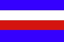
Prague (Praha) Flag 1784
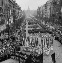
The city that we call Prague today was first made the capitol of Bohemia when the Austrian Emperor Josef II ordered four small side-by-side towns built along the Vltava River to be united and ruled by one Magistrate in 1784.
Since the the magistrate offices were located in the Old Town Hall the arms and flag of Old Town became those of the new capital. Unfortunately, they were identical with colors of the Hapsburg dynasty which made the Prague "landesfarben" unpopular among Czech citizens and because of this they would eventually change their colors in 1886. Today's Prague flag has a yellow (top stripe) and red (bottom stripe). |
.gif)
The Prague Banner
.jpg)
|
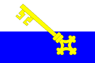
The Prague Banner c1477
During the Hussite Wars when the City of Prague was attacked by "Crusader" and mercenary forces, the city militia fought bravely under this banner. It was later captured by Swedish troops on their raid in 1649 and eventually placed in the Royal Military Museum in Stockholm; today it is simply called the "Prague Banner."
The swallow-tailed banner was approximately 4 by 6 feet, with a red field sprinkled with small white fleurs-de-lis, and a silver old Town Coat-of-Arms in the center. The words "PÁN BÚT POMOC NASSE" (The Lord is our Relief) appeared above the coat-of-arms, with a Hussite chalice centered on the top. Near the swallow-tails is a crescent shaped golden sun with rays protruding.
When the Banner was first made and used is open for debate, but earliest evidence indicates that a gonfalon was used for Old Town as early as 1419 with some municipal charge painted on it. This particular municipal militia flag was used before 1477 during the Hussite Wars, which now makes it the the oldest still preserved municipal flag in Bohemia.
Although this flag still exists, it is in very poor condition, and the original shades of its colors are hard to determine accurately because of its faded condition. The monochrome drawing shown here of the Prague Banner was done by the Swedish painter Olaf Hoffmann in the late 1600s, and even then it had deteriorated. |
.jpg)
Staré Mesto gonfalon
(after 1886)
.jpg)
Nové Mesto gonfalon
.jpg)
Malá Strana and Hradcany
gonfalon
|
The future Czech capital grew up on both the right and left banks of the Vltava River between two castles named "Pražský hrad" (Prague Castle) and "Vyše hrad" (Higher Castle).
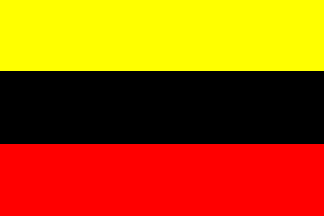
Old Town (Staré Mesto) Flag 1477
Old Town is the oldest part of Prague and was a medieval town fortified behind protective walls as early as 1257. It was also known as "Greater Town." In 1477, the Bohemian King Vladislaus II divided the flag of Old Town into three stripes of red, yellow, and white replacing the older black and yellow of the Hapsburgs.
In 1886, a local Czech painter named B. Wachsmann was asked by the Municipal Council to design a new city arms, colors, and seals using the colors yellow and red for the city of Prague. These new colors had replaced the older the Old Town colors by the Jubilee Exhibition in 1891.
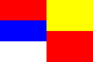
New Town (Nové Mesto) Flag 1348
New Town bordered the fortified Old Town, but wasn't within the protective walls. It began as the poorer part of the town located across the Vltava from Prague Castle and it was administered separately. It grew as the population in Old Town outgrew the area within the walls. The Holy Roman Emperor Charles IV made Prague his capitol and encouraged the enlarging of New Town. He also enlarged the Prague walls to include New Town. He connected Lesser Town to New Town with the famous Charles Bridge. He had the order of the red and yellow stripes changed on the New Town flag.
Lesser Town (Malá Strana) and Hradschin-Castle (Hradcany) c1320
Both Lesser Town and Hradcany used the same colors. The Town of Hradcany began as a humble little town located directly west of Prague Castle just outside the castle walls. It was started as a business venture by a leading Prague Burgrave (Count) named Hynnek Berka of Duda around 1320. As time passed it grew and prospered and filled with royal residences. Lesser town was located to the south and below Hradcany on the left bank of the Vltava River beneath Prague Castle's protective walls. Lesser Town, founded in 1257, provided one of the first market places of the future Prague.
These four towns became the first four quarters of the City of Prague. |
.jpg)
Jewish Town Flag
|
Jewish Town (Josefov) Flag c1350
Josefov (Joseph's City) is the Jewish quarter in Prague today. It is named after the Austrian Emperor Josef II. It is a completely new city quarter constructed where the medieval "Jewish Town" was located. In 1262, King Premysl Otakar II (1230-1278), one of the greatest rulers of Bohemia, granted the medieval Jewish Town community a degree of self-administration.
Evidence indicates that the very first Jewish flag with a six-pointed star might date from this Jewish community of Prague, when they were ordered in 1354 to display a red banner charged with the Star of David, or Solomon's Seal, by Charles IV, the King of Bohemia, and the Holy Roman Emperor. Although the original banner has been lost, the banner became the symbol of Jewish Town. In 1926, Josefov became the fifth quarter of Prague. |
.jpg)
Mount Vyšehrad gonfalon
|
Town of Mount Vyšehrad Flag c1450
Vyšehrad (Higher Castle) is where Prague's second royal castle was built designed to monitor access to the Prague Valley. It existed as early as the 10th Century as a fortress, but became a royal residence during the reign of King Vratislav I of Bohemia (1061-1092). A church consecrated to St. Peter and Saint Paul was also built on the hill at this time. Large-scale building work was undertaken in the reign of Charles IV, but the castle was attacked and destroyed by Hussite forces in 1420. The walls were torn down and the area basically added to that of neighboring New Town.
In the 1600s the area was once again slowly transformed into a massive Baroque citadel as part of Prague's defense system, and it finally gained real municipal status in 1850. In 1883, it became the the sixth quarter of Prague. |
.jpg)
Zižkov gonfalon
|
Town of Zižkov Flag 1881
To the east from the historical Prague town center, the Town of Zižkov could be found. Zižkov was granted municipal status in 1881. It was named after the one-eyed Hussite leader and military commander, Jan Žižka, who defeated Emperor Sigismund on the hill called Vítkov (located between Zizkov and Karlin quarters today). Today, most of Zižkov lies in the municipal and administrative district of Prague 3. The quarter that bears Žižka's name was always considered as a borough with rough and dodgy inhabitants, and Zižkov is the Bohemian part of Prague with many artists living or performing there.
It is said that Zižkov has the highest number of pubs per capita in Europe. It was historically a working-class district, and was sometimes referred to as "red Zizkov," because so many of its inhabitants were members of the Communist party. In Zižkov, you can find the grave of Jan Palach, student that burnt himself to death in 1969 in protest at the Soviet invasion of Czechoslovakia, and the grave of famous novelist Franz Kafka is in the "new" Jewish cemetery. |
.jpg)
Holešovice-Bubny gonfalon
|
Communities of Holešovice and Bubny Flag 1926
The name of Holešovice is first mentioned in historical records in 1228 as a royal property. It was a small farming hamlet that in the mid-19th century was gradually transformed into a Prague city suburb. Nearby Bubny was known for its fisheries. In 1884, Holešovice was merged with Bubny into a single Prague urban district. From the end of the 19th century Bubny was directly connected with Prague by a chain bridge and served mainly as a district of residential apartment blocks, while Holešovice concentrated more on building factories and became a peripheral industrial district.
Holešovice and Bubny never achieved municipal status before becoming the seventh quarter of Prague in 1884. They were given the colors of white and red for their flag in 1926. |
.jpg)
Libín gonfalon
|
Town of Libín Flag 1901
Libín has been a town since 1898, but the first mention of Libín was in 1363. It became the eighth quarter of Prague in 1901. Among the attractions are Libín mansion, where a peace treaty was signed (also known as Libenský peace) between Rudolf II and his brother Matthew in 1608.
Today, Libín is an urban district and cadastral territory (land administrative divisions, used for taxes), extending into parts of Prague 8, Prague 7 and Prague 9. Both Libín, and nearby Vysocany, have become centers of the Czech steel industry with many steel workers living and working in the two neighboring communities. Most residential buildings are only a multilevel brick houses. But a few modern buildings appear there as well. Both the Rokytka and Vltava Rivers flow through Libín territory, and water from the Vltava River caused much damage during the flooding in 2002, both in Libín and in Palmovka. |
.jpg)
Vysocany gonfalon
|
Town of Vysocany Flag 1902
Although the history of the Vysocany settlement dates further back, one of the most significant turning points in the town's history was in 1896 when the Krizik's Electric Tramway was started connecting it and other communities with the rapidly growing Prague. Vysocany was granted municipal status in 1902. At that time, Vysocany had 4,000 residents and was building a new City Hall which is still an impressive structure today. When Great Prague was established in 1922, Vysocany was one of the 37 incorporated municipalities. It has become a part of Prague IX.
Vysocany became an important center of transport and the food industry. Vysocany served as a manufacturing site for the locomotive producer CKD, the Praga Car Factory, the Kolben Factory and Avia Aero, among others. It reached its peak during World War II and continued into the 1950s. |
.jpg)
Karlín gonfalon
|
Town of Karlín Flag 1904
Karlín was founded in the beginning of 19th century (1817), originally as an independent municipality. The area was mainly covered by fields, meadows, vineyards, and a few buildings. One of the most important structures built before Karlín's official founding was the "Invalidovna," a large Baroque-style complex designed as a dormitory for war invalids (veterans) modeled after the French "hôtel des invalides." It was completed in 1737. Today, it serves as an army archive center.
Karlín was granted municipal status in 1904, and gained administrative independence in 1903. Between 1903 and 1914, many streets in the newly regulated area were developed. Karlín became a part of Greater Prague in 1922. The district also developed into an important industrial center where factories were concentrated, mostly in the western section. |
.jpg)
Královské Vinohrady gonfalon
|
Town of Královské Vinohrady Flag 1879
The name Vinohrady means "vineyards." The area was covered with vineyards starting in the 14th century when Czech King Charles IV had them planted there, right around the time when he had New Town built. The vineyards lasted for some four hundred years and were later replaced by rose gardens, orchards, and residential buildings. An independent community of Vinohrady was established in 1849, encompassing the area of today's Vinohrady and Zižkov. The area was divided into Kralovske Vinohrady (Royal Vinohrady) and Zižkov in 1875. Kralovské Vinohrady received the status of a city in 1879.
Vinohrady is one of he most beautiful residential area of Prague and has a reputation of prestige and elegance. Kralovské Vinohrady was incorporated into Greater Prague as a district in 1922 and its name was shortened to Vinohrady in 1968. It covers portions of Prague 2, 3, and 10. Most of its grand Neo-Renaissance, Art Nouveau, Pseudo Baroque, and neo-Gothic buildings come from the second half of the 19th century and first half of the 20th century, and many have been and continue to be restored in an amazing array of color and architectural detail. |
.jpg)
Vršovice gonfalon
|
Town of Vršovice Flag 1902
The origin of Vršovice dates back to the dwellings in the valley of Botic, to the time when the first counts settled in Vyšehrad. The settlement included the Vyšehrad Abbey, and a fortress. The economic life of Vršovice moved around the fort for many centuries. During the rule of Charles IV the slopes of the Botic valley were turned into vineyards. However, during the 30 Years War much of the area was destroyed. In 1420, the village witnessed the defeat of King Zikmund when the troops of the Czech King George of Podebrady attacked Vyšehrad.
In 1797, Jakub of Wimmer (1754-1822) purchased the town. Wimmer, an officer of the Austrian army, introduced modern methods in agriculture, such as grafting, to the area, and built orchards and vineyards for which the area became famous. Vršovice was granted municipal status in 1902. |
.jpg)
Nusle gonfalon
|
Town of Nusle Flag 1898
Nusle is located two kilometers south of the Prague City Center in Nuselské údolí (Nusle Valley) on the Botic. It is bordered by Vyšehrad to the west, the New Town and Vinohrady to the north and Vršovice to the east. The southern part of Nusle, on a plain above the valley, is known as Pankrác. Nusle became a district of Prague in 1922, but had been granted municipal status in 1898. Today, part of Nusle is in Prague 4 while the balance is in Prague 2.
Nusle is home to the Nuselský bridge (Nusle Bridge), the highest bridge in Prague and reported to be one of the largest in the Czech Republic. It does not span the Vltava, but runs over the Nusle valley and connects the opposite sides of the valley. The Nusle Bridge is 530 yards long and its height over the valley is 131 feet. Over 300 people have committed suicide by jumping from it since 1973, when the bridge was finished. |
.jpg)
Smíchov gonfalon
|
Town of Smíchov Flag 1904
This quarter was mentioned for the first time at the end of the 13th century in connection with the coronation of the Czech king Wenceslas II (1271-1305). Since the Middle Ages the prevailing part of this territory was occupied by vineyards, hop-fields, yards, fields and gardens belonging to the Church. Mills were built along the river.
In the 19th century, Smíchov idustrialized and many factories were built; the quarter quickly became a "hundred-chimney Manchester." Since 1848, Smíchov has been self-governed, and after that it became one of Prague's suburbs. In the second half of the 19th century, the townhall, the Church of St Wenceslas, and some residential houses and neighborhoods for workers were added to the growing Smíchov .
Today, most of the factories have been demolished or renovated into modern houses, and the industrial areas were replaced by shopping centers and hotels. The quarter still retains an unique character famous for its bars and night life. Smíchov was granted municipal status in 1904. In the Prague administrative division, Smichov is the central part of Prague 5. |
.jpg)
Košíre gonfalon
|
Town of Košíre Flag 1894
Košíre used to be a village until the second half of the 19th century. Their development continued with a growing industry and need for accommodation for migrating workers. Košíre was granted municipal status in 1894. Between 1896 and 1921 it was a town. In 1922, it became part of Greater Prague.
Today, the Košíre district, and cadastral area, is located in the valley between two stream, the Smichov and Motol. They are part of the city and municipal district Prague 5. |
.jpg)
Brevnov gonfalon
|
Town of Brevnov Flag 1907
The Brevnov Monastery is the oldest monastery in the Czech Republic. In 993 Prince Boleslav II and Bishop Vojtech established the abbey not far from the Prague Castle near the village of Brevnov for the order of the Benedictine monks. The Brevnov Monastery became an important political, cultural and economic center. The first monastery buildings were pillaged by the Hussites in 1420 and once again by Swedish troops during the Thirty Years' War. During the 16th and 17th centuries the church was repaired several times and a new convent was built. The monastery once again suffered war damage in the middle of the 18th century, and was later decimated by the reforms of Emperor Josef II and then, after the arrival of communism, the monastery was abolished.
Only after the fall of the totalitarian regime and the general repairs carried out in the years 1990–1994 did the Brevnov Monastery once again serve the monastic community, and with its promotion to an arch-abbacy in 1993, it once again took its place amongst the leading religious centers in Europe. |
Bubenec gonfalon
|
Town of Bubenec Flag 1904
Bubenec is located two kilometers north of the Prague City Center. The Sewage Plant in Bubenec is the oldest sewage treatment plant in Prague, designed by William Heerlein Lindley, and built between 1895-1906. In 1991, the whole building was declared a protected national monument. Bubenec was granted municipal status in 1904.
It contains Stromovka Park, the largest of Prague's city parks that was made from a splendid old royal hunting grounds. Stromovka Park is considered as one of the most beautiful in the Czech capital. In this area you will find an interesting planetarium, zoo, botanical gardens. North of Stromovka and Bubenec you will find Troja with its marvelous castle and botanical garden. |
.jpg)
Uhríneves gonfalon
|
Town of Uhríneves Flag
The history of Uhríneves goes back to the 13th century. Earliest records of it dates from 1227, when, under the name "Vgrinewez" it appears in the list of places. Another mention is in a document from 1228, when the property is registered as the Ugrín Monastery of St. George at Prague Castle. At that time it was named as Ugrín Village. It probably got its name after its founder Ugrím, who settled here and established a settlement. It also contains a Jewish cemetery, which was established in early 18th century, called Aurinowes. Headstones are still legible from as early as 1719.
The biggest development of Uhríneves was in 19th century. The village became a small township in the year 1866. Its development as a township, both in agriculture and industry continued, until in 1913, the township was granted municipal status and a year later was approved for a city symbol, designed by the academic painter Henry Bubenicek, which is still used today as a coat-of-arms of the city of Prague 22. Today, Uhríneves is located 14 kilometers southeast of the Prague City Center. |
.jpg)
Horní Pocernice gonfalon
|
Town of Horní Pocernice Flag
Horní Pocernice was only granted municipal status in 1969. Modern "Upper Pocernice" emerged in 1943, connecting the communities of Chvaly, Svépravice, Certousy, Xaverov to the existing village of Horní Pocernice. In 1974, the Upper Pocernice was connected to Prague and incorporated into the municipal district of Prague 9, but they kept their own local national committee. In 1990, the territory was transformed into the city of Prague-Horní Pocernice. In 2002, it became part called of the new district of Prague 20. |
.jpg)
Zbraslav gonfalon
|
Town of Zbraslav Flag
The Town of Zbraslav was founded in 1118. Today, it is the "southernmost" district of Prague on the Vltava River in the national administrative district (správní obvod) of Prague 16. It entered into history during the reign of Wenceslas II, who, in the year 1297, held a magnificent coronation banquet there for, according to the chronicles of that time, 190,000 noble guests and their entourage. Wenceslas II built a cloister for monks of the Cistercian Order in Zbraslav called "Aula regia" which became the burial place for Bohemian kings. Unfortunately, this famous Gothic Cistercian Cloister was totally destroyed at the beginning of the Hussite Wars. Above Zbraslav, on the other bank of the Vltava River there is also evidence of an ancient Celtic Fortress, whose 170 hectares was surrounded by 9 km of complex ramparts.
Zbraslav was granted municipal status in 1935, and was merged into Prague in 1974. The current restored Baroque version of the cloister, with its adjoining park, houses the Asian Art collections of the National Gallery. Zbraslav was also the residence of songwriter Jaromír Vejvoda (1902-1988), best known internationally for "The Beer Barrel Polka." Today, it is mainly a residential community. |
.jpg)
Modrany gonfalon
|
Town of Modrany Flag
The oldest written record of Modrany dates back to 1178, when Bohemian Duke Sobeslav II dedicated "the area at Modrany town on two ploughs with a vineyard" to the Vysehrad Abbey. The name of Modrany probably comes from blue color of grapes. Modrany has been an agricultural village for a long time. The sugar refinery, which is one of the oldest in Europe, was the first industrial factory.
Within a rapid development of Prague in the end of the last century, Modrany became an attractive place for building villas in the 1930s. By 1936, Modrany became a well-known market place, and in 1967, it was proclaimed to be an independent town. In 1991, Modrany became District Prague 12. At present this district incorporates parts of municipalities Cholupice, Kamyk, Komorany, and Modrany a Tocna. |
.jpg)
Radotín gonfalon
.gif)
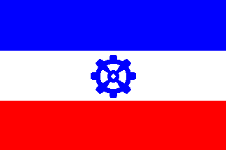
Radotín Flag 1991 |
Town of Radotín Flag 1971
Radotín has a long history. It was first mentioned in historic chronicles in 993 when the area was given to the monastery in Brevnov, which is today part of Prague 6. In 1153, it was referred to again, this time as an important river crossing on the road to the historic south Bohemian towns of Tabor and Pisek.
For a long time, Radotín remained just a small agricultural village, but that changed in the 1870s when the Prague-Plzen Railroad Line was built. The railway brought economic development. A marble factory, a sugar refinery, and a cement works were established. An aircraft component factory and a ventilator factory are among the town's other industrial enterprises. Radotín was granted municipal status in 1971. Today, Radotín has become more of a middle-class neighborhood than an industrial one.
When it was discovered that the tricolors of the town flag of Radotín was identical to the new flag of Yugoslavia, it had to be modified in 1991. A rule of thumb exists that a municipal flag cannot be identical with any existing state or national flag, so a cogwheel was added to the design used in the Czech Republic. |
.jpg)
Dubec gonfalon
|
Town of Dubec Flag
The first mention of Dubec dates back as early as 1088, during the reign of Prince Vratislav. The origin of the name of the village is derived from oak (dub in Czech). According to some sources there was a large oak forest found in the vicinity which produced a lumber indrustry. The name Dubecis a derivation from the word used for workers specializing in logging and processing timber, mostly oak. Dubec was a forestry settlement serving Prague. In 1502, during the reign of John Dubecského of Dubec, the village was promoted to a town by King Vladislav II Jagiello, King of Bohemia and Poland.
Today, Dubec is a cadastral area in the southeast of Prague, and is part of the city district Prague 10.
|